My wife (Lesli) and I decided to take a road trip during our vacation period at the end of September, and when the opportunity arose, we jumped into a rental car and headed east across British Columbia on the Crowsnest Highway (BC Hwy #3). It was an experience we'll never forget.
 |
| Our Trip Map (Google map + edits by Kati) |
Note: I wrote about the case in our previous blog: Calling Spirit Energy. Give it a read before you continue here, to get a full picture of what was going on.
Our trip began in Vancouver BC, and after reaching Hope, where we took a quick break at a Service Station and joined the Crowsnest Hwy #3, we arrived at our first stop a few kilometres east of the small district municipality.
1) The Hope Slide - a place I had visited as a child with my family, and several times since. It always gave me a feeling of doom, but this time it felt peaceful. Something tells me the spirit(s) of the people who had died in the largest landslide in Canada, had moved on.
 |
| The Hope Slide - landmark sign (photo by Kati) |
 |
| The Hope Slide - a memorial marker (photo by Kati) |
 |
| The Hope Slide - Kati & Lesli standing at the base of the slide (photo by Kati) |
On August 13, 1965, that same year, a small aircraft crashed into the area killing the pilot.
On April 23, 1966 a Royal Canadian Air Force Grumman CSR-110 Albatross crashed on the Hope Slide killing 5 of the 6 crew members.

I said a silent prayer as we paid our respects, sending good thoughts and energy to those that had died; and off we drove to our next destination along the Highway, a few hours east of Hope.
2) Hedley, BC -
--> Here's an interesting video to watch about the history of this small town: Hedley
 |
| "Ore train, Nickle Plate Mine, Hedley, BC" (Oct.1909) courtesy BC Archives |
 |
| Unknown Date - Tramway at Nickel Plate Mine - courtesy of VPL.ca |
 |
| Hedley Cemetery - sign seen on BC Hwy#3 heading west (photo by Kati) |
 |
| (photo by Kati) |
 |
| (photo by Kati) |
 |
| (photo by Kati) |
The air was warm and dry with dust kicking up in a slight wind from time to time as we walked around the cemetery. Many of the grave markers cite the "flu epidemic", and a large number indicate the short lives of those interred at the cemetery. It truly was remarkable. The cemetery had a feeling of peace about it, and as we walked through reading the names out loud, sending good vibrations to those that had gone before us, we felt all was well. There were so many graves marked with white crosses that bore no names or dates. A section was divided off for the Masonic area (founded on the principles of Brotherly Love, Relief, and Truth, the Masons are a pure "fraternal" society dedicated to the principle of support and relief for members), and another had a sign that read "Loyal Order of Moose" (a fraternal and service organization founded in 1888). Someone had placed white crosses and white rounded bed knobs alternating on the fence surrounding the entire cemetery, which made for a beautiful sight. As we were taking a break in our vehicle, another drove up carrying a group of young women. It seemed they were just as interested in the cemetery as we were.
With the sun dropping, we decided to head east and look for a place to stay for the night. Osoyoos, BC, a border town in the Okanagan Valley boasting the mildest winters in Canada.
 |
| Osoyoos Lake - view south to USA border (photo by Kati) |
3) Phoenix, BC - much of the remaining dilapidated buildings in this Ghost town (at 4630+ feet above sea level) were levelled in the 70's when an open pit mine was created; however, the pioneer cemetery still stands to this day. Established in 1901 with the first burial in 1902.
--> An interesting video about Phoenix is Here.
Copper had been discovered in the Phoenix area in 1891 and a settlement began named "Greenwood Camp". It wasn't until 1896 that the output of the copper mines was exceeding every other in BC and two years later the town was renamed "Phoenix" which grew to include its own Post Office, Hospital, Banquet Hall, Opera House, Stagecoach Line, City Hall, Ice Rink, 20 Hotels and even a Brewery. The 1000+ citizens called it "the highest city in Canada". The copper mine ceased operations on June 14, 1919, when the Granby Company loaded the last trainload of ore. As the town was reliant on the industry and the price of copper had dropped after the First World War, people left their belongings and homes and the town began to die. It became the largest Ghost Town in Canada. In the 1950s (to 1978) an open mine pit began, and thus buildings were bulldozed and lost forever.
Three men remained after everyone had left. William Bambury (Englishman, the last resident to be buried in the cemetery in December 1951), Bob Denzler (American prospector, died 1944) and Adolph Sercu (Belgian prospector better known as "Forepaw, became appointed watchman of the Ghost Town - died 1942, buried in the cemetery).
 |
| Winnipeg Tribune (Dec06/1906) - Ad - courtesy Newspapers.com |
 |
| Phoenix Cemetery (photo by Kati) |
 |
| Phoenix Cemetery (photo by Kati) |
 |
| Phoenix Cemetery (photo by Kati) |
 |
| Phoenix Cemetery (photo by Kati) |
 |
| Phoenix 1910 - courtesy BC Archives |
 |
| Phoenix 1946 - courtesy BC Archives |
 |
| Phoenix area today (photo by Kati) |
 |
| Winnipeg Tribune (Mar09'1910) courtesy Newspapers.com |
 |
| (photo by Kati) |
4) Greenwood, BC - incorporated in 1897 and known as Canada's smallest city located in the southern Kootenay Boundary region, boasts some of the best preserved heritage buildings in BC. Due to the downturn of the copper market, Greenwood was affected much like Phoenix, but it also relied on logging as an industry, which employs many people of the area to this day. By the 1940's only 200 people remained, down from the approximate 3000 in 1899. Greenwood became the first internment camp for 1200 Japanese in 1942. Many of the empty buildings were used to house the influx of families.
 |
| Greenwood Post Office (photo by Kati) |
 |
| Greenwood Fire Department building (photo by Kati) |
 |
| Sign explaining the Landmark (photo by Kati) |
 |
| (photo by Kati) |
 |
| (photo by Kati) |
 |
| (photo by Kati) |
 |
| (photo by Kati) |
The next morning, after a cup of coffee (or two), we welcomed the blue sky day with adventure. Here we had to leave the Crowsnest Highway to visit our next stop.
5) Fort Steele, BC - this heritage town is easy to spot. Northeast of Cranbrook, along BC Hwy 93/95, it is situated next to the Kootenay River with Fisher Mountain (in the Purcell Mountains) to the east.
The town is linked to the discovery of gold in the area in the 1860s. John Galbraith saw a need for a ferry service across the Kootenay River and started one up, thus a small number of buildings sprung up around his office, which then became known as Galbraith's Ferry. Land disputes began between the Ktunaxa Nation and the newcomers, and when tensions peaked in 1887, Superintendent Samuel B. Steele and members of the North West Mounted Police arrived to resolve the problems. It was established as the first post west of the Rockies, and in 1889 the NWMP left the area. Residents of the area petitioned the Dominion Government to rename the settlement Fort Steele in honour of the Superintendent. In 1892, silver, lead and coal were discovered nearby bringing prospectors into the area. In 1898 the town boasted 11 hotels, 4 restaurants, 4 general stores, a brewery and hardware store plus more. An estimated 1000 people lived in the commercial, social and administrative centre. The railway bypassed the town in favour of Cranbrook, and thus the decline of Fort Steele began. In 1961 the town was declared a historic park by the Government, and today it is one of the most important living history museums of its kind.
I remember visiting this park in the 1960s as a child. My parents took the family on a camping trip which brought us through the area. Memories of a rail car with a "golden toilet" come to mind. I asked the museum about this, as I was certain I had not been dreaming. The informative attendant confirmed my thoughts and advised that particular train was given back to England some years ago. The reason the toilet was golden had to do with a member of the Royal Monarchy having sat on it. Who that member was, I can't remember. A Duke or possibly Queen Elizabeth (the Queen Mother, wife of King George VI).
This heritage town-site is a step back into the past and a must see attraction. One can wander about, enter buildings, learn about the history of the area, take numerous tours, enjoy the food services and more.
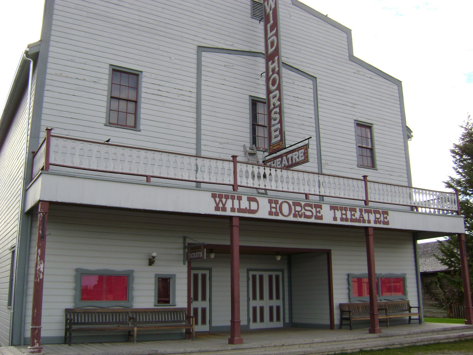 |
| Wild Horse Theatre (photo by Kati) |
 |
| View east outside of Windsor Hotel (photo by Kati) |
 |
| Painless Dentistry! (photo by Kati) |
 |
| Sign at the Dentist Office (photo by Kati) |
 |
| Telephone & Telegraph building (photo by Kati) |
 |
| Inside St. Anthony's Roman Catholic Church circa 1897 (photo by Kati) |
 |
| Schoolhouse room (photo by Kati) |
 |
| View of the town-site east (photo by Kati) |
 |
| Deteriorating cabin & the Water Wheel (photo by Kati) |
 |
| Deteriorating House (photo by Kati) |
 |
| Queen Cabin - brothers, trappers/hunting guides home (photo by Kati) |
 |
| Tin Shop (photo by Kati) |
 |
| International Hotel which boasts a restaurant "Cuisine of Superior Excellence" (photo by Kati) |
 |
| View north (photo by Kati) |
 |
| View north (photo by Kati) |
 |
| Water Tower (photo by Kati) |
 |
| From the Water tower view east (photo by Kati) |
 |
| From the Water tower view north (photo by Kati) |
 |
| From the Water tower view west (photo by Kati) |
6) Saint Eugene's Mission - heading northwest from Cranbrook, along BC Hwy 95A, we took a right hand turn onto Mission Road and followed this towards St. Mary River. Now known as St. Eugene Golf Resort & Casino, the Spanish-colonial-styled resort was once a Residential School for First Nations youth.
 |
| St. Eugene's Mission - Golf Resort & Casino (photo by Kati) |
 |
| Mission building built in 1910 (photo by Kati) |
 |
| Mission building built in 1910 (photo by Kati) |
I was driven to enter the old Mission building, so Lesli and I climbed the stone steps to the main floor entrance, and walked on through the doors. It was beautiful! Bricks and wood came together creating each room with a warmth. Old photographs were displayed along the walls to honour the memories of what had been before. I could see the sadness and anxieties felt when looking at the children in some of the aging photographs. History was thick with abuse, segregation and punishment on the children for over the 60 years. We found a washroom and I took a moment to swallow what was welling up inside of me. Then we proceeded to walk through some of the rooms and along hallways. I was entranced, and once outside at the top of the stairs, I felt an overwhelming urge to cry.. and so I did. Letting it all go on the lawn, in front of the building, I was filled with incredible sorrow and shame. Was I feeling the energy of the children who were forced to attend the school? I had been drawn to one photo in particular that showed a young native girl (possible 8 or 10 years of age), standing in front of a group of children, looking at the photographer with pain in her eyes. Was it her feelings I was letting out? I just know, it was a journey I needed to take.
 |
| St Eugene's Mission circa 1926 - courtesy BC Archives |
 |
| An old photo of the house. |
We can say our visit with the family that evening was remarkable. Their home was inviting and warm. Lesli and I tackled different areas of the home to listen, ask questions (while recording the sessions), and open ourselves up to feel what was there. A message came to both of us, while we were in different parts of the house, allowing us to feel that the imposing energy was that of a nature path. Possibly a pagan or land energy that was blowing itself up larger than it truly was, and this was causing harm to the family. We put away our equipment after a good thorough investigation, and decided to cleanse the house with the homeowner leading the way. You can read about our "Home Blessing/Cleansing" methods at our website.
Afterwards, we felt a fog had lifted and hugged the homeowner, let her know we would be checking in from time to time. All evidence would be reviewed from our recordings and that we'd share with her our findings. A short while after we arrived home, we discovered some evidence and placed two recordings at our website HERE. You can listen to them and comment to us. They are the two labelled "September 2016".
That evening, while asleep, I had a dream of an angel I called "Floyd". He was surrounded with blue-white light which was brilliant and clean. He spoke "say bye bye to the beast" and smiled. I don't remember all the details but my wife heard me talking in my sleep and recorded the conversation I was having. Incredible!
Our client remarked that her family had not experienced such a good sleep in a long time. She advised us the house had fallen silent and no further activity has been reported to this day. Hurray!
Back to our trip...
7) St. Eugene's Cemetery - I had read about a small cemetery in the area, so the following morning after checking out of our hotel and grabbing a large cup of fresh coffee, we drove back to the Mission. Among dry overgrown grasses in a field nearby, we could see white crosses dotting the area. Out of respect, we stayed back on Mission land and took photos from a distance.
 |
| At the edge of the Golf course you can see the Cemetery (photo by Kati) |
 |
| Ktunaxa Nation Cemetery (photo by Kati) |
 |
| Ktunaxa Nation Cemetery (photo by Kati) |
Approximately 30 kilometres west outside of Cranbrook we passed the small town of Moyie. To our right was Moyie Lake, and to our left we could see a very small cemetery hidden among the trees on a hill side. We had two big cemeteries to explore before nightfall, so we left this one for another time. I am sure we'll embark on this journey in our future to include more fascinating places all the way to the Alberta border and possibly beyond. So we drove on.
Driving the highway through a town called Salmo, we noticed a road sign that read "Cemetery Road" which turned off towards the right. You bet we took that one. It was on my list of places to explore.
8) Salmo Cemetery - The village was originally known as Salmon Siding (named for the original name of the Salmo River, i.e. the Salmon River). It was founded as a small mining and logging town near the Nelson/Fort Sheppard Railway during the gold rush of 1896. It changed to "Salmo" to avoid confusion with other places with similar names. The village is nestled in the Selkirk Mountains and was known for the abundance of large salmon in the Salmo River before the dams on the Columbia River were built.
 |
| Vancouver Daily World - Salmo Ad (Mar16'1897) courtesy Newspapers.com |
 |
| Salmo Cemetery (photo by Kati) |
 |
| (photo by Kati) |
 |
| (photo by Kati) |
 |
| (photo by Kati) |
A two hour drive west, we found another road sign that read "Cemetery Road" and once again, we took the turn off the Crowsnest to explore.
9) Midway Cemetery - The Cemetery was established in the early 1900s and is still actively used today. Located within the Kootenay Boundary District in a rural area of Midway. It is maintained by the town of Midway, Mile 0 of the Kettle Valley Rail Trail. There are approximately 166 internments most with headstones. There are large unmarked areas that may also have internments.
 |
| (photo by Kati) |
 |
| (photo by Kati) |
 |
| (photo by Kati) |
 |
| (photo by Kati) |
 |
| (photo by Kati) |
Midway
became the western terminus of the Columbia Western Railway (owned by CPR), and
the village boasted 5 hotels, meat market, dry goods store, pharmacy, bakery,
wagon and carriage builder, stationery shop, sawmill and a stagecoach company. The
following decade railroad companies fought to run lines through the area, and
by 1910 three railway lines connected with Midway. Jan.17, 1964 the last Kettle
Valley Line passenger train passed through Midway. Gold and railroads were of
the past; and today the lumber industry & tourism are the strength of the
village.
On August 25, 1908 Charles L Thomet was shot and killed by two masked men who entered the Midway Hotel believed to be in search of him. Thomet was owner of the hotel, retired from the BC Provincial Police only two years earlier. It was believed the two men had held up another hotel a few days prior, and that Thomet recognized them.
On August 25, 1908 Charles L Thomet was shot and killed by two masked men who entered the Midway Hotel believed to be in search of him. Thomet was owner of the hotel, retired from the BC Provincial Police only two years earlier. It was believed the two men had held up another hotel a few days prior, and that Thomet recognized them.
 |
| Courtesy of BritishColonist.ca - Victoria Daily Colonist (Aug.28'1908) |
 |
| Thomet, Charles L (unknown date) |
 |
| Death Certificate - Charles L Thomet (d.Aug25'1908) courtesy Familysearch.org |
 |
| Midway Hotel (circa 1935) - courtesy BC Archives |
 |
| Vancouver Daily World (Sep.24'1908) - courtesy Newspapers.com |
 |
| Vancouver Daily World (Oct.01'1908) - courtesy Newspapers.com |
 |
| Winnipeg Tribune (Feb.02'1909) - courtesy Newspapers.com |
 |
| Thomet's grave marker (photo by Kati) |
The sun was dropping in behind the mountains and so we decided to get back on the road and make our goal of reaching Osoyoos in just under an hour later. Of course we had a fright along the way.. what? A Sasquatch crossing a road that met up with the highway? Let's go back and have another look.
 |
| Wait! Is it? A Sasquatch? (photo by Kati) |
 |
| Alas it was a statue next to a road called Sasquatch Lane (photo by Kati) |
 |
| Osoyoos Lake & the city below (photo by Kati) |
Minutes later we found ourselves looking down into a valley with Osoyoos Lake and the city below. What a beautiful view! With our ears popping all the way down the mountain, we finally made it onto the small strip of land crossing the lake, where our hotel waited with a warm comfy bed for the night. That evening we rested peacefully after a long day of travelling and exploring.
The next morning, to be our last one of the trip, we found a Tim Horton's (Yes, there are truly many Timmy's scattered across this land.. but no Starbucks.) for a rather large cup of coffee and soon we were on the highway again. Heading west we had a plan to take a turn off through the town of Princeton BC and head along a windy mountain road to the Ghost Towns of Coalmont and Granite Creek City.
10) Granite Creek Cemetery - Gold was first discovered on Granite Creek approximately in 1858. While white miners considered it low grade and soon abandoned the area, the Chinese stayed on mining the area until 1883. Then in July 1885, a major gold strike occurred, and Granite Creek grew to over 2,000 people, mostly miners looking to strike it rich. By 1886 it was reported to have 40 houses, 6 saloons, 7 stores, several hotels, and became the third largest community in BC. The gold supply soon dwindled and by the turn of the century it was practically deserted. A major fire on April 4, 1907 destroyed most of the derelict buildings. The cemetery overlooks where the town once stood.
 |
| Welcome to Granite City (photo by Kati) |
 |
| What is left of the city (photo by Kati) |
 |
| Granite Creek & cabin circa 1890 - courtesy granitecreekbc.ca |
 |
| Sign to the Cemetery (photo by Kati) |
 |
| Our first view of the Cemetery (photo by Kati) |
 |
| The view of the city site below (photo by Kati) |
 |
| (photo by Kati) |
 |
| Amy Lucas (Rhodes) 1907-1992 (photo by Kati) |
 |
| Among the dry trees & pine needles (photo by Kati) |
 |
| (photo by Kati) |
 |
| (photo by Kati) |
 |
| (photo by Kati) |
 |
| Cemetery Index (photo by Kati) |
 |
| William Moses (d.1957) & Butch (d.1955) (photo by Kati) |
 |
| "Lyddian Bryant" grave died Mar.02, 1898 (photo by Kati) |
 |
| "Rossiter" family deaths in 1929, 1932, 1952 (photo by Kati) |
 |
| Manitoba Free Press (Sep24'1885) courtesy Newspapers.com |
 |
| Vancouver Daily World (Aug23'1892) courtesy Newspapers.com |
 |
| Chilliwack Progress (Jun12'1895) courtesy Newspapers.com |
 |
| Vancouver Daily World (Aug12'1911) courtesy Newspapers.com |
 |
| Coalmont Hotel (photo by Kati) |
 |
| Death Certificate - Hattie McBride (d.Nov21'1920) courtesy Familysearch.org |
 |
| Hattie McBride (d.Nov21'1920) (photo by Kati) |

 |
| Vancouver Daily World (Dec07'1920) Murder of Hattie McBride - courtesy Newspapers.com |
Our day was more than half over and we still had a few hours drive back to Vancouver. Driving the long windy, narrow road back through to Princeton, where we joined the Crowsnest Highway, we felt happy at our discovery. This time our trip seemed to go by quickly, since we knew the area. Past the Hope Slide and into Hope BC we drove, where we took another break at a gas station. We checked into our online feeds (Twitter and Facebook) and then decided to drive the last stretch home into the West End of Vancouver. Unfortunately there had been an accident on Highway #1, which delayed our arrival by a few hours. We spent the time laughing about silly ideas that popped into our heads, and talked about our experiences on the trip.
Once home, after unloading the car, we sat down to relax and enjoyed the evening catching up on paranormal shows we had missed during the week. It's always good to be home, but we'll never forget this amazing trip across the province of BC, nor the wonderfully kind people we met, or the truly fascinating places we explored.
Thank you to our friends in the Kootenays, and those we met at the different stops we made. Thank you to the hotels in Osoyoos and Cranbrook for their comfy beds and good service, and thank you to the Province for the amazing historical places we were able to explore, not to forget the Rest Areas along the highway for our convenience.
Let us know if you've ever travelled the Crowsnest Highway in BC and what wonders you've explored along your journey. We'd love to hear from you!
Until next time,
Safe ghost hunting!
Kati
Sources: Photos by Kati - all are copyright & require permission from Kati Ackermann Webb & vancouverspooks.com to use them for any purpose.
Wikipedia; BCArchives; Ghosttowns.com; Hedleybc.ca; Greenwoodcity.com; GreenwoodMuseum.com; nelsonstar.com; Canadiantraveller.com; Hellobc.com; milebymile.com; columbiavalley.ca; itsmysite.com/bchistory; fortsteele.ca; steugene.ca; kimberleykeepers.ca; historicplaces.ca; "Ghost Town Stories 3" - Johnnie Bachusky; crowsnest-highway.ca; Coalmonthotel.com; Ancestry.ca; FamilySearch.org; Newspapers.com; BC Archives; and Google Maps.


I lived in Nelson for 8 years until 2002 when I moved back to the coast. I wish that I had included cemeteries in my exploring the Kootenays so I enjoyed your post. I also wish that I had paid more attention to spirits which sometimes appear to me. What comes to my mind is the Nikkei Centre in New Denver, the little town of Ymir which was a haven for American outlaws, and the areas along the Arrow Lakes where the Kootenay people lived. The Doukhobors have a violent history and Peter the Lordly is interred in Castlegar after he was blown up on a train. There is a definite energy in this area, known by the native people who lived there. On a ley line. kinda like Sedona. I found my soul there.
ReplyDeleteHey K! Thanks for your thoughts & comment. So happy to hear you enjoyed our post. I wish we had time to include the Doukhobor cemeteries scattered in between Grand Forks and Castlegar areas. Alas, we only had so much time, so a further trip will be in our future I'm sure! I've heard many stories that speak to violence and I'm sure if I dig in the archived newspapers I'll find plenty of evidence. I'm interested.. for sure! I've always thought of ley lines and where they may be in our Province, as I had investigated this theory in Sonoma County, California. Whenever we go on any investigation I make a point to notch it on a map. I want to see the lines created and where they lead. Opening up to receiving messages is never a bad thing when investigating. Whenever I discover a piece of evidence that validates what we receive.. WOW! It knocks my socks off! And for Lesli & I to connect with "similar" messages.. confirms that we are all connected. Keep an eye on future blogs. I have so much to research and present to everyone. I'm just happy when people tell me I have pushed a button, or connected with them. Thanks again! Kati
ReplyDelete